

GEOMETRY & CAPTURE FOR PROJECTION MAPPING
Know the canvas.
Create the moment.
Behind every remarkable projection is a physical surface.
We capture the shape, so your team can create the experience.
One surface. A different possibility in every plane.

THE PHYSICAL / DIGITAL CONNECTION
The experience is extraordinary.
The starting point is real.
A facade is more than an outline. An arch has depth. A show set has edges, recesses and details that change how an image reads.
We capture that geometry for projection studios, scenic fabricators and AV teams. A shared spatial reference brings the physical surface into the creative conversation.
Meet the surface behind the showTHE CANVAS / IN 360°
Step around the surface.
See what light can change.
A flat image hides the depth. Explore an architectural surface, then change the projection to see how the same shape becomes a different visual experience.
Rotate the view. Switch the light. Discover what changes.
Drag to orbit once the scene is open. The view angle control also works with a keyboard.
Geometry capture supports a production team’s planning; final projection coverage, media and calibration depend on its equipment and on-site setup.
FROM SURFACE TO SHOW
Follow the shape.
See the handoff.
Explore how physical conditions become a measured reference, then enter a creative and technical workflow. Capture supplies the geometry; your production partners bring media, systems and on-site calibration.
Physical environment
Identify the real surface and the decisions your team needs to make. Existing models and drawings are useful inputs; their relationship to the built condition needs review.
- Physical environment
Identify the real surface and the decisions your team needs to make. Existing models and drawings are useful inputs; their relationship to the built condition needs review.
- Capture planning
Define mapped surfaces, adjacent context, access windows and the detail required. Plan around occlusion, finishes, operational restrictions and significant changes.
- 3D laser scanning
Measure visible surfaces from planned positions. Coverage depends on access and line of sight; transparent, reflective and hidden features can need special consideration.
- Point cloud
Individual scan positions produce spatial measurements. These are evidence of captured conditions, rather than a finished production model.
- Register & review
Align scan positions into a shared reference, review coverage and registration, and document the coordinate system, exclusions and limitations.
- Production geometry
When included in the scope, develop the measured reference into a surface mesh or model. Agree detail, simplification, units and any UV responsibilities.
- Creative & AV integration
The receiving teams use the agreed geometry for media development, previsualization, fabrication coordination or projection planning. Confirm imports before production depends on them.
- Calibrate & show
The AV team aligns and calibrates the projection system to installed conditions, reviews the content and commissions the show. A scan supports this work; it does not replace it.
Physical environment
Identify the real surface and the decisions your team needs to make. Existing models and drawings are useful inputs; their relationship to the built condition needs review.
Capture planning
Define mapped surfaces, adjacent context, access windows and the detail required. Plan around occlusion, finishes, operational restrictions and significant changes.
3D laser scanning
Measure visible surfaces from planned positions. Coverage depends on access and line of sight; transparent, reflective and hidden features can need special consideration.
Point cloud
Individual scan positions produce spatial measurements. These are evidence of captured conditions, rather than a finished production model.
Register & review
Align scan positions into a shared reference, review coverage and registration, and document the coordinate system, exclusions and limitations.
Production geometry
When included in the scope, develop the measured reference into a surface mesh or model. Agree detail, simplification, units and any UV responsibilities.
Creative & AV integration
The receiving teams use the agreed geometry for media development, previsualization, fabrication coordination or projection planning. Confirm imports before production depends on them.
Calibrate & show
The AV team aligns and calibrates the projection system to installed conditions, reviews the content and commissions the show. A scan supports this work; it does not replace it.

THE PLACES / THE PEOPLE / THE POSSIBILITIES
Your world.
Your workflow.
From a sculpted attraction facade to a room that surrounds an audience. Start with the space and the people who need to understand it.
Find the capture questions that matter to your workflow.
Theme parks & attractions
- Typical challenge
- Existing attractions combine scenic detail, operating constraints and changing show requirements.
- Where capture fits
- Capture the relevant facade, show set or environment around agreed access and production milestones.
- The handoff
- A shared spatial reference for designers, content studios, fabricators and AV partners.
Theme parks & attractions
Existing attractions combine scenic detail, operating constraints and changing show requirements.
Capture the relevant facade, show set or environment around agreed access and production milestones.
A shared spatial reference for designers, content studios, fabricators and AV partners.
Scenic fabrication
Installed or fabricated forms may differ from design drawings and need to interface with new work.
Document built surfaces and spatial relationships at the stage that supports the fabrication or media decision.
Measured reference geometry for comparison, coordination and a separately agreed modeling scope.
Projection mapping studios
A beautiful design model may not describe the actual projection surface well enough for the content workflow.
Establish measured surface geometry and discuss how it becomes a usable production model.
An agreed reference with scale, orientation, surface priorities and model responsibilities made explicit.
AV & systems integration
Projection planning depends on surface relationships, surrounding context and reference features.
Capture the relevant environment to support spatial planning alongside the integrator’s optical and calibration work.
A consistent spatial reference for system planning, previsualization and on-site alignment discussions.
Museums & cultural attractions
Exhibits and heritage spaces combine interpretive media with sensitive physical environments.
Plan non-contact measurement around collections, public access and the surfaces that carry the story.
Spatial context for exhibition designers, content teams and AV partners.
Immersive experiences
Dimensional media spaces need physical and digital teams to work from consistent geometry.
Document the surfaces, boundaries and surrounding relationships that the experience depends on.
A common reference for content, scenic and technical development.
Experiential agencies
Creative intent moves between several suppliers and may encounter incomplete or changing site information.
Create an agreed spatial starting point and define who receives, reviews and transforms it.
A documented geometry handoff that connects site conditions with a partner-led creative production.
THE SPECIALIST SCOPE
Capture with
the next team in mind.
Define the surface, the decision and the handoff. These services give your team a spatial starting point for the production ahead.
3D laser scanning for projection mapping
Capture the physical geometry behind the creative work.
Reality capture for projection mapping
Connect existing conditions to a shared spatial reference.
Projection surface capture
Focus on the edges, depth and detail that shape the image.
Point cloud & 3D spatial data
Define the handoff before the data arrives.
WHY GEOMETRY MATTERS
A flat outline misses
the third dimension.
Edges, recesses and changing planes influence how media meets a surface. A measured reference helps teams discuss those relationships.
Move the depth control to see how a recess changes the surface. Switch between point markers, connected faces and reference features to compare the information each layer provides.
Understand the geometryVPM / SURFACE STUDY 001
Same architecture.
A moving canvas.
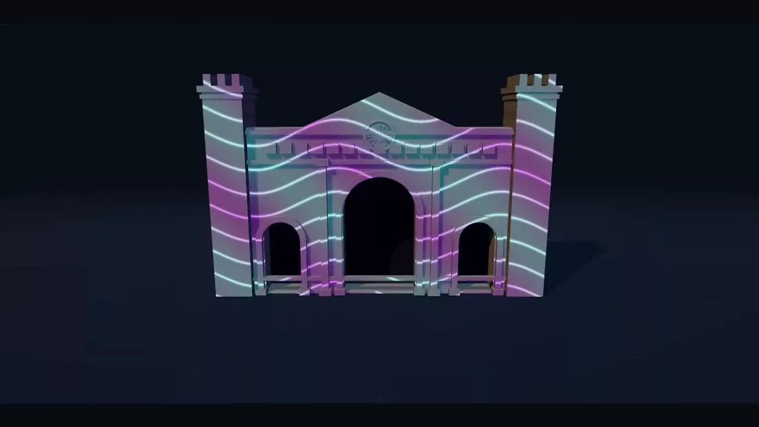
Watch light move across the facade. The camera changes perspective while the surface stays in place, revealing the edges and recesses beneath the image.
24-second visual study, without audio. Cyan and violet contours move over a virtual stone facade as the view rotates to reveal its thickness, cornices and recessed arches. The geometry gives the projection its shape.
PRACTICAL KNOWLEDGE
See more.
Ask better questions.
From surface to experience in projection mapping
How physical shape, audience viewpoint and production geometry connect in a projection-mapped experience, and where capture fits into the process.
Read the guideWhy surface geometry matters to projection mapping
Depth, edges, occlusion and viewpoint explain why a physical projection surface is more than a flat image boundary.
Read the guidePlan a reality capture before media production depends on it
A practical briefing guide for projection studios, attraction operators, scenic fabricators and AV teams planning spatial capture.
Read the guidePoint cloud versus mesh: what your production team needs
Understand measured points, registered spatial data and derived surface models before specifying a projection mapping handoff.
Read the guide